
N. 49 SAVANNAH CIUDADES IMAGINADAS, CIUDADES REALIZADAS. Desde Al Rawda a la Estación Espacial Internacional.

http://www.art.com/products/p14145299-sa-i2815540/joanne-wells-historic-wormsloe-plantation-savannah-georgia-usa.htm
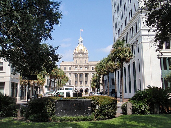
La propuesta para el módulo urbano básico que se desarrolla en Savannah es con mucho una de las propuestas más brillantes y simples, claras, creadoras de recintos de habitación, cuyo diseño propositivo se ejecutó en América Colonial de acuerdo al plan original. Además en su fundación hubo un componente multiétnico que encontró en cada plaza un centro de arraigo que caracterizó este plan social y edificatorio al mismo tiempo tan complejo, pero resuelto con sencillez.


http://www.columbia.edu/itc/architecture/wright/6769_2002/images/week2/week2.html
La ciudad fue diseñada y trazada en el propio terreno por el General Británico James Oglethorpe, los primeros colonos eran ingleses y escoceses, Judíos Portugueses y españoles expulsados de Europa. En primer lugar se edificaron tres núcleos básicos con sus características plazas, a los que luego se anexionaron 19 más para así guiarse por el plan maestro del general británico que pretendía 24 recintos.


http://www.massieschool.com/exhibits/oglethorpes-city-plan-2
El urbanismo colonial norteamericano de ciudades nuevas planificadas como Philadelphia y Savannah va en cierta forma a ser un caso antecesor del urbanismo colonial español en la ciudad planificada de Guatemala, no se trata de la misma corriente de pensamiento, pero de nuevo las plazas se multiplican en el trazado urbano como constituyentes de identidad de los diferentes sectores y alrededor de las cuales se edificarían edificios públicos relevantes como las cedes del gobierno, o la autoridad religiosa, uso de las plazas que alcanzará su máximo desarrollo en la ciudad de Savannah.


http://ookaboo.com/o/pictures/topic/13286887/Squares_of_Savannah
Savannah is known as America's first planned city. Oglethorpe laid the city out in a series of grids that allowed for wide open streets intertwined with shady public squares and parks that served as town meeting places and centers of business. Savannah had 24 original squares; 22 squares are still in existence today.[1]


http://georgiainfo.galileo.usg.edu/tdgh-feb/feb09.htm
Sin duda alguna las pequeñas plazas son el alma de la ciudad, sobre ellas gira el uso de los edificios públicos, las manzanas de edificios con diferentes tamaños y formas que se agrupan en torno al vacio arbolado responden a diferentes funciones como las iglesias o el mercado. Cada módulo mínimo permite una variedad y mixtura de las funciones urbanas. Sin embargo en cierta época se decide abandonar el tipo de planificación por adición de módulos básicos y entonces la ciudad alcanzaba 22 módulos tradicionales, luego de esta etapa la ciudad se extiende conservando parte de la geometría ortogonal, pero se introduce el concepto del suburbio como en otras ciudades.


http://georgiainfo.galileo.usg.edu/tdgh-feb/feb09.htm
City Squares of Historic Downtown Savannah, Georgia
The city of Savannah, Georgia was originally laid out in 1733 around four open squares. The plan anticipated growth of the city and thus expansion of the grid; additional squares were added during the eighteenth and nineteenth centuries, and by 1851 there were twenty-four squares in the city. In the early twentieth century, three of the squares were demolished or altered beyond recognition, leaving twenty-one squares. (One of the three is currently being reclaimed.) Most of Savannah's squares are named in honor or in memory of a person or persons or a historical event, and many contain monuments, markers, memorials, statues, plaques, and other tributes.


http://www.loc.gov/exhibits/treasures/tri036.html
The city of Savannah was founded in 1733 by General James Oglethorpe. Although cherished by many today for their aesthetic beauty, the first squares were originally intended to provide colonists space for military exercises. The original plan resembles the layout of contemporary military camps, which were likely quite familiar to General Oglethorpe. The layout was also a reaction against the cramped conditions that fueled the Great Fire of London in 1666, and there is speculation that Oglethorpe's military studies had made him familiar with the similar layout of Beijing.


http://mapas.owje.com/maps/9946_plan-of-the-city--harbour-of-savannah-in-chatham-county-state-of-georgia-united-states-a.d.-1818.html
A square was established for each ward of the new city. The first four were Johnson, Wright, Ellis, and St. James (now Telfair) Squares, and themselves formed a larger square on the bluff overlooking the Savannah River. The original plan actually called for six squares, and as the city grew the grid of wards and squares was extended so that twenty-four squares were eventually created at the nodes of a six-by-five grid. (Two points on this grid were occupied by Colonial Park Cemetery, established in 1750, and four others—in the southern corners of the downtown area—were never developed with squares.) When the city began to expand south of Gaston Street, the grid of squares was abandoned and Forsyth Park was allowed to serve as a single, centralized park for that area.
 http://mapas.owje.com/maps/9948_savannah-sewage-map-state-of-georgia-united-states-1880.html

All of the squares measure approximately 200 feet from north to south, but they vary east to west from approximately 100 to 300 feet. Typically, each square is intersected north-south and east-west by wide, two-way streets. They are bounded to the west and east by the south- and north-bound lanes of the intersecting north-south street, and to the north and south by smaller one-way streets running east-to-west and west-to-east, respectively. As a result, traffic flows one way—counterclockwise—around the squares, which thus function much like traffic circles.
Each square sits (or, in some cases, sat) at the center of a ward, which often shares its name with its square. The lots to the east and west of the squares, flanking the major east-west axis, were considered “trust lots” in the original city plan and intended for large public buildings such as churches, schools, or markets. The remainder of the ward was divided into four areas, called tythings, each of which was further divided into ten residential lots. This arrangement is illustrated in the 1770 Plan of Savannah. The distinction between trust lot and residential lot has always been fluid. Some grand homes, such as the well-known Mercer House (also featured on this page), stand on trust lots, while many of the residential lots have long hosted commercial properties.


http://thecorreareport.blogspot.com/2009/06/savannah-paradigm-of-self-sufficiency.html
All of the squares are a part of Savannah's historic district and fall within an area of less than one half square mile. The five squares along Bull Street — Monterey, Madison, Chippewa, Wright, and Johnson — were intended to be grand monument spaces and have been called Savannah's "Crown Jewels." Many of the other squares were designed more simply as commons or parks, although most serve as memorials as well.

http://www.lawnandlandscape.com/ErrorPage.aspx?aspxerrorpath=/Classifieds/Default.aspx
Architect John Massengale has called Savannah's city plan "the most intelligent grid in America, perhaps the world," and Edmund Bacon wrote that "it remains as one of the finest diagrams for city organization and growth in existence." The American Society of Civil Engineers has honored Oglethorpe’s plan for Savannah as a National Historic Civil Engineering Landmark, and in 1994 the plan was nominated for inclusion in the UNESCO World Heritage List. The squares are a major point of interest for millions of tourists visiting Savannah each year, and they have been credited with stabilizing once-deteriorating neighborhoods and revitalizing Savannah's downtown commercial district.[2]

http://christophtallerico.blogspot.com/2010/08/5-reasons-why-savannah-is-perfect.html
Es posible que estos modulos urbanos mínimos en cierta forma auto suficientes fueran entidades sociales discretas, cada uno albergaría a un sector de la comunidad que comparte características similares, como por ejemplo el modulo judío o el modulo británico o el escocés, generándose barrios y comunidades con cierta cohesión y diferenciadas de otras, pero que comparten la vida cotidiana en la ciudad, así se multiplicarían también las posibilidades de los gremios económicos asociados al clan etnico.
http://blog.travelpod.com/travel-photo/bdsaly/2/1284382070/john-wesley-is-remembered-in-a-savannah-square.jpg/tpod.html
En cierta forma la autonomía de cada una de las unidades mínimas de urbanismo que se adicionan a la gran composición urbana hubiesen sido en cierta manera antecesoras de las mega manzanas autosuficientes que Le Corbusier propone para Chandigarh o Meier y Costa para Brasilia, esta multitud de plazas tiene su primer antecedente dentro del escaso grupo de ciudades planificadas en los ejemplos de Palmanova y Grammichele, pero sin duda el uso más sofisticado en medio de la simpleza es el que presenta Oglenthorpe en Savannah.


http://www.georgiaencyclopedia.org/nge/Multimedia.jsp?id=m-2540
Sería muy interesante conocer de dónde se tomó esta idea, qué antecedentes tuvo en el contexto británico y qué influencias tuvo en la planificación de nuevas ciudades en los Estados Unidos, ya que de alguna manera cada modulo urbano mínimo es como una ciudad, que llega a componer una gran ciudad muy bien balanceada entre el lleno y el vacío.
No hay comentarios:
Publicar un comentario